

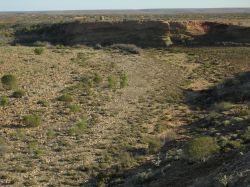
Looking downstream over Andamooka Waterhole, the bluff and John McDouall Stuart's stone cairn.
Entries from John McDouall Stuart's Journal
Reproduced below are the entries from three days, taken from the journal of John McDouall Stuart. The first is from the camp at Andamooka Waterhole. The others are from not long afterward and mention the trouble they were having with horse shoes on the rocky ground, a recurring issue for the duration of the expedition.
Monday, 21st June, Water Creek. Started at 9.30 a.m. on a course of 25 degrees.
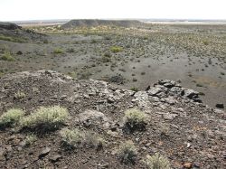
The view of Willaroo Lagoon from the top of the flat topped, iron stone hill, described by John McDouall Stuart.
At a mile passed a small table-topped hill to the west of our line; at three miles and a half crossed the creek; at four miles passed another table-topped hill connected with the low range to the east, and passed the first ironstone hill; at seven miles changed to 55 degrees; at eight miles halted at a large permanent water hole (Andamoka).
I can with safety say that this is permanent; it is a splendid water hole, nearly as large as the one at the mouth of the gorge in the John.
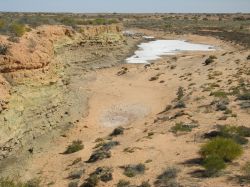
Thick salt in the creek downstream from Andamooka Waterhole.
The low range to the east of our course, and running nearly parallel with it, is composed of conglomerate, quartz, and a little ironstone. Part of to-day's journey was over low undulating sandy and very well grassed country.
There seems to have been a little rain here lately; the grass is springing beautifully.
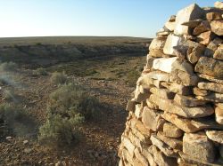
Looking from John McDouall Stuart's stone cairn toward the low range in the east.
At eleven miles we came upon a salt lagoon (Wealaroo) two miles long by one broad. From the north end of it, on a bearing of 55 degrees, one mile and a half will strike Andamoka.
I think we have now left the western sand hills behind us; and now that we have permanent water to fall back on, I shall strike into the north-west to-morrow.
The distance travelled to-day was fifteen miles.
The country around this water consists of bold stony rises and sand, with salt bush and grass; no timber except mulga and a few myall bushes in the creek. On an examination of the creek, we have found salt water above and below this hole. In one place above there are cakes of salt one inch and a half thick, a convincing proof that this is supplied by springs.
Friday, 25th June, Yarraout Gum Creek. Started at 9.40 from the point where we first struck the creek last night, bearing 20 degrees for two miles, thence 61 degrees for one mile to a high sand hill, thence 39 degrees for one mile to a stony rise.
My doubt of the black fellow's knowledge of the country is now confirmed; he seems to be quite lost, and knows nothing of the country, except what he has heard other blacks relate; he is quite bewildered and points all round when I ask him the direction of Wingillpin.
I have determined to push into the westward, keeping a little north of west. Bearing 292 degrees for five miles, sand hills; thence 327 degrees to a table-hill nine miles. Camped without water. Our route to-day has been through sand hills, with a few miles of stones and dry reedy swamp, all well grassed, but no water.
We came across some natives, who kept a long distance off. I sent our black up to them, to ask in which direction Wingillpin lay. They pointed to the course I was then steering, and said, "Five sleeps." They would not come near to us.
About three-quarters of an hour afterwards I came suddenly upon another native, who was hunting in the sand hills. My attention being engaged in keeping the bearing, I did not observe him until he moved, but I pulled up at once, lest he should run away, and called to him.
What he imagined I was I do not know; but when he turned round and saw me, I never beheld a finer picture of astonishment and fear. He was a fine muscular fellow, about six feet in height, and stood as if riveted to the spot, with his mouth wide open, and his eyes staring. I sent our black forward to speak with him, but omitted to tell him to dismount. The terrified native remained motionless, allowing our black to ride within a few yards of him, when, in an instant, he threw down his waddies, and jumped up into a mulga bush as high as he could, one foot being about three feet from the ground, and the other about two feet higher, and kept waving us off with his hand as we advanced. I expected every moment to see the bush break with his weight.
When close under the bush, I told our black to inquire if he were a Wingillpin native. He was so frightened he could not utter a word, and trembled from head to foot. We then asked him where Wingillpin was. He mustered courage to let go one hand, and emphatically snapping his fingers in a north-west direction, again waved us off. I take this emphatic snapping of his fingers to mean a long distance. Probably this Wingillpin may be Cooper's Creek.
We then left him, and proceeded on our way through the sand hills.
About an hour before sunset, we came in full sight of a number of tent and table-topped hills to the north-west, the stony table land being to the south of us, and the dip of the country still towards Lake Torrens. I shall keep a little more to the west to-morrow if possible, to get the fall of the country the other way.
The horses' shoes have been worn quite thin by the stones, and will not last above a day or two. Nay, some of the poor animals are already shoeless. It is most unfortunate that we did not bring another set with us.
Distance to-day, twenty-four miles.
Sunday, 27th June, Large Water Creek. Cloudy morning, with prospect of rain.
A swan visited the water hole last night, and to-day we have seen both the mountain duck and the large black duck.
Having a shoe to fix upon Jersey, and my courses to map down, we did not get a start until 10 o'clock, and we were obliged to stop early in consequence of the grey mare getting so lame that we were unable to proceed. We had an old shoe or two, and Mr. Forster managed to get one on the mare.
We started to-day on a bearing of 270 degrees for eight miles to a low flat-topped hill, when we changed to 220 degrees for five miles to a gum creek with rain water. About five miles to the north of our line there are flat-topped ranges, running north-east. The main creek runs on the south side of this course, and nearly parallel to it. Further to the south, at a distance of about ten miles, is still the stony table land with the sand hills. The country is fearfully stony, but improves a little in grass as we get west. It seems to be well watered.
Distance to-day, about twelve miles.
Information source: The University of Adelaide Library